 Baden-Oos
Validation date: 25 04 2015
Updated on: 13 09 2015
Views: 8092
See on the interactive map:
48°47'33"N 008°11'14"E
Runway: 04L/22R - 3280x98ft - grass
Runway: 04R/22L - 3937x98ft - asphalt (CLOSED)
(due to displaced tresholds 3642ft if coming from 04R, 3445ft if coming from 22L)
Baden-Oos airfield (German: Flugplatz Baden-Baden, Flugplatz Baden-Baden/Oos or Flugplatz Baden-Oos, ICAO: EDTB) was an airfield 550 kilometers southwest of Berlin.
The airfield opened in the spring of 1910 and drew worldwide attention for having the first operational airship hangar, measuring 160x30x30meter (lxwxh). In addition it featured a hydrogen gas installation for 12,000m/sq and a railroad connection to deliver that gas.
Curiously, the opening of the airfield was not through airships, but for mono- and doubledecker aircraft during a flying meet. During the meet, German pilot Behrend achieved an alitude of 30 meter (just under 100 feet), while his colleague Jeannin managed to take his Aviatik double decker to a staggering 74 meters (ca. 225 feet). The official opening occurred as planned on 21 August 19190, with the arrival of the 144m long airship LZ6. Two days later, LZ6 made Germany's first official passenger revenue flight: twelf passengers had paid 200 Mark for a two hour long scenic tour over the region. Such flights took place daily until 14 September 1910, when a fire burned the skin of LZ6. Fortunately, the hydrogen did not fill the hangar but instead drifted outside before it burned off without causing major damage. LZ6 was beyond repair however: only its bent aluminium frame remained.
Later that year DELAG (Deutsche Luftschiffahrts A.G.) began to operate an air service from Frankfurt to Baden-Baden with airship LZ7.
Baden-Oos is also significant because it was the location where a young Dutchman tried to fly his first aircraft, called "Spin" (dutch for Spider). Although he crashed his first 'Spin' in October 1910, he later became of world fame for the very successful range of 211 aircraft types he and his company designed: Anthony Fokker.
The final airship flight from Baden-Baden to Frankfurt (made by LZ11) started on the early evening of 12 July 1914. With the expected outbreak of war, the german War Ministry took over control of the passenger airships Viktoria Louise, Hansa and Sachsen and civillian airtravel was halted. The airship hangar was also confiscated and used for combat Zeppelins. From 1917 the airfield was also used as a storage and salvage center, where old aircraft were brougt and recyled for spare and other usable parts. Altogether 3300 aircraft were processed and up to 280 people found work at the site.
Baden-Oos as a storage and reclamation facility in 1917 (flugplatz-baden-oos.de).
After the end of the war, the hangar was sold to the city of Baden-Baden, who were owner of the ground anyway. For the first few years after the war, the hangar was used for the fabrication of glider aircraft. However, the stipulations of the Versailles Treaty meant that the hanger was to be torn down and sold. It was ultimately sold for 295,000 Mark. Part of the hangar is still in use as a wood mill in Auggen, 120 kilometer to the south.
The airfield became the production location for Segelflugwerke G.mb.H., the first facility for series production of glider aircraft, which was renamed Weltensegler-gesellschaft in 1922. Their aircraft did not fly from Baden-Oos however, instead, they were taken to hilltops in the nearby Black Forest.
Map of Baden-Oos in 1931 (PENNULA.de)
After World War II, the airfield was assigned to the French occupation forces in Germany. To support the French Armed Forces Headquarters in Baden-Baden, a small liaison aviation unit of the ALAT, the Light Aviation unit of the Armée de Terre (French army), was operating from the airfield under different names. In 1960 however, restrictions for civilian flying in Germany were lifted and the airfield returned to civilian flights. That same year Baden-Oos held its first international used aircraft fair. Two years later, the flying clubs began building their own hangars.
A photo taken in 1960 during the first International Used Aircraft Fair at Baden-Oos (flugplatz-baden-oos.de)
In this photo, taken from the north in 1964, Baden-Oos appears without a hardened runway (flugplatz-baden-oos.de).
A new hardened runway was built in 1970, a new hangar in 1974 and another International Used Aircraft Fair was held in 1976. A final hangar was built in 1987/1988. Throughout the 1970s and 1980s, the airfield continued as a civilian airfield, although the ALAT remained at the airfield until the French withdrawal from Germany in the late 1990s.
Approach to Baden-Oos, ca. 1974. The hardened runway is clearly visible, to its right, a white glider can be seen on the shorter grass runway (flugplatz-baden-oos.de).
Overview of the Internationale Gebrauchtsflugzeugmesse (IGM, or International Used Aircraft Fair) in 1976 (flugplatz-baden-oos.de).
Baden-Oos marked with a 'B' as a 'Mil Flgpl FAF' (Mil Airfield Fr Air Force) on an aviation map found at pennula.de
Baden-Oos as an active airfield in May 1993. A large number of gliders and a similar amount of GA aircraft are seen on the airfield (IGN.fr)
From 1997, civilian aviation moved from Baden-Oos to the former Canadian air base CFB Baden-Söllingen, which was abandoned by the Canadians on 31 December 1993. Only the local glider clubs were allowed to remain at the airfield, which was then (by law) changed to a "special category airfield" (german: Sonderländeplatz). It remains in use as such to this day.
Baden-Oos, with closed runway in October 2000 (Google Earth)
Baden-oos in June 2002. Although the hardened runway is marked with large 'X' markings to indicate it is closed, the grass runway remains in use for the glider club (IGN.fr)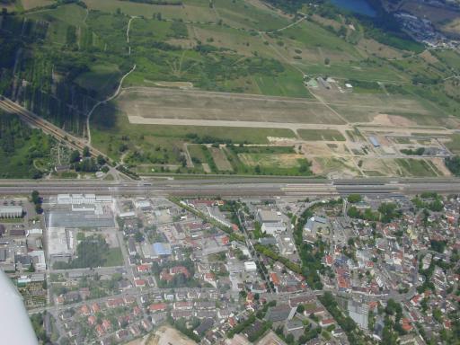
The remains of Baden-Oos in 2003 (kienzi.ch).
Baden-Oos had lost half the runway as well as the French ammunitions complex by 2006. (Google Earth)
Only the grass runway for the gliders remained in the Summer of 2009. Commercial buildings were beginning to appear on the southeast side of the former airfield (Google Earth).
 Baden-Oos