 Khersones (Херсонес)
Validation date: 12 05 2014
Updated on: Never
Views: 5687
See on the interactive map:
44°34'46"N 033°23'33"E
Runway: 01/19 - 1850x35m - concrete
Khersones airfield (Ukrainian: Херсонес аэродром, sometimes also known as Sevastopol South airfield or the Khersonesos Lighthouse airfield) was an auxiliary airfield on Cape Khersones on the Crimean peninsula, 680 kilometers south of Kiev.
The airfield already existed when the German Wehrmacht was battling the Crimean in 1942. The Sevastopol area was the scene of some of the war's heaviest fighting and Sevastopol with the Khersones airfield was one of the last resistance nests. Although the defenders of the city surrendered on 12 July 1942, fighting did not end until the 17th.
Map of Khersones airfield during the 1942 battle with the Wehrmacht. The North is on the left side of the map (divingsport.org)
After the capture, the Luftwaffe turned the airfield into a repair facility. In addition it was used as a liaison airfield. The German occupation lasted until May 1944, when control was taken back by the Red Army. 
Burnt out remains of a Luftwaffe Fw190D at Khersones after the Soviets recaptured the Crimea in 1944 (englishrussia.com)
Under Soviet control, little is known of the airfields history, even from Ukrainian and Russian sources. What is known is that the Soviets built a Ballistic Missile Early Warning System (BMEWS) on the west side of the airfield in the 1970s, with large Dnepr 'Hen House' radars becoming operational between 1974 and 1979.
In addition the airfield was used as an auxiliary airfield to train Kamov Ka-25 'Hormone' crews for some time, possibly because the airfield was surrounded by the Black Seaon three sides. The base personnel were housed in barracks with bunk beds and with so many people, it constantly felt overcrowded. In the summer it was hot in the barracks and in the late autumn and winter cold. Personnel sometimes slept in their outerwear and fur jackets. In the winter time the period of stay on the airfield was reduced as much as possible. During the warmer months crews were at the airfield for up to three weeks. On the northeast side of the airfield, a military catecean 'research' facility was located, listed as secret "military unit 13132-K" or "Area 75".
Ka-25 'Hormone' helicopters parkes at Khersones airfield (prnhistory.net)
After the breakup of the Soviet Union in 1992, the Crimea became part of Ukraine. The BMEWS-site was run by the Ukranians with the data being sent to the Russian Early Warning headquarters in Solnechnogorsk. In 2008, the Russians announced they were to end the agreement in 2009. The last data was sent on 26 February 2009 after which the Ukranian government announced the site would be used for space surveillance after a one month maintenance. Since, the site lies abandoned with complete panels of the radar array missing. Although the airfield appears abandoned, the runway and southern platform appeared well kept in 2013 photography. The northern dispersal area had copious amonts of grass growing between the concrete slabs however.

Khersones and the BMEWS stite to the west in 2007 (forum.sevastopol.info)
The abandoned control tower as photographed in 2010 (Napshivalov Roman)
The treshold of runway 19 photographed in 2011 by Oleksa Haiworonski on Flickr.
One wing of the 'Hen House' radar with many panels missing can be seen in this July 2012 photo of the BMEWS site and the Cape Khersones lighthouse (navolne.net.ua).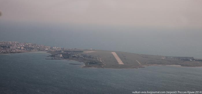
The airfield photographed from the north on 21 April 2014 by Andrei Ivanov on Wikimapia, well after the Russian invasion of the Crimea . Oddly, there still were no X markings visible on the runway to indicate the airfiels is closed.
 Khersones (Херсонес)