 Sandtoft
Validation date: 29 09 2012
Updated on: 23 03 2015
Views: 7305
See on the interactive map:
53°33'52"N 000°51'51"W
runway: 06/24 - 1830x50m/6000x150ft - concrete (CLOSED)
runway: 05/23 - 886x18m/2909x59ft - asphalt
runway: 12/30 - 1280x50m/4200x150ft - concrete (CLOSED)
runway: 17/35 - 1280x50m/4200x150ft - concrete (CLOSED)
Sandtoft air field (RAF Sandtoft, ICAO: EGCF) is a former RAF bomber airfield, 235 kilometers north-northwest of London.
The airfield opened in February 1944 as a satellite airfield to RAF Lindholme, located only 5 kilometers to the west. Elements of 1667 Heavy Conversion Unit operated from the airfield with Handley Page Halifaxes and Avro Lancasters. The station had so many crashes it became known locally as 'Prangtoft'. The station moved from 1 Group to 7 Group Bomber Command in November 1944. It was closed on 10 November 1945.
No photos of RAF Sandtoft before 1985 have been located
After the Second World War, the airfield was placed on care and maintenance. It remained inactive until allocated to the United States Air Force on 1 April 1953. However, the station was never occupied by the USAF. It was returned to Ministry of Defence control on 8 September 1955 and put up for disposal. In 1968 part of the former airfield was sold to what was to become the Trolleybus Museum at Sandtoft. Other parts were converted for industrial use. On the southern taxi track a flying club settled, using one of the taxitracks as a runway. The airfields runways remained relatively intact until the late 1980s. Durint the last decade of the 20th century large surfaces were convered with concrete to serve as car parks.
A small museum, featuring a Gloster Meteor, a Bloodhound SAM and a Fairy Gannet, appeared to be building up at the airfield. In aerial photography from 2008 they had all disappeared however.
former RAF Sandtoft, photographed from the northeast, ca. 1988 (AirfieldinformationExchange).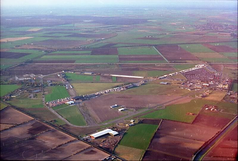
Former RAF Sandtoft, photographed from the south, August 1997 (AirfieldinformationExchange).
Overview of former RAF Sandtoft in 2002 (Google Earth).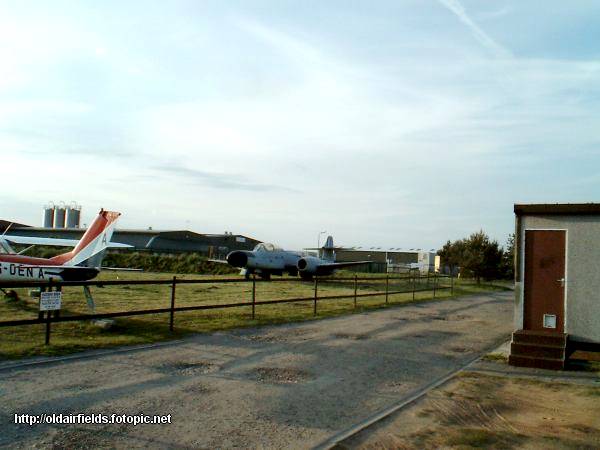
The Gloster Meteor near the entrance of the airfield sometime around 2003 (raf-lincolnshire.info). 
Sandtoft Aerodrome runway, the picture shows the runway of the present day aerodrome photographed on 21 March 2006 (David Squire on Geograph.org.uk)
The small GA runway was resurfaced with fresh asphalt in the final months of 2009. In April 2012 the GA-airfield was put up for sale.
Today many of the original buildings still exist. The original control tower for instance was converted into a home in 1979. From the air, much of the airfields former layout can still be recognised.
Overview of former RAF Sandtoft in 2009 (Google Earth).
On approach to Sandtoft in September 2010 (fightercontrol.co.uk).
2012 Sandtoft aerodrome (EGCF) chart (Eurocontrol).
Former RAF Sandtoft photographed from the North on 22 March 2015 (Magnus Emanuelsson via email)
 Sandtoft