 Venosa
Validation date: 30 03 2011
Updated on: 06 05 2017
Views: 6925
See on the interactive map:
40°59'49"N 015°52'37"E
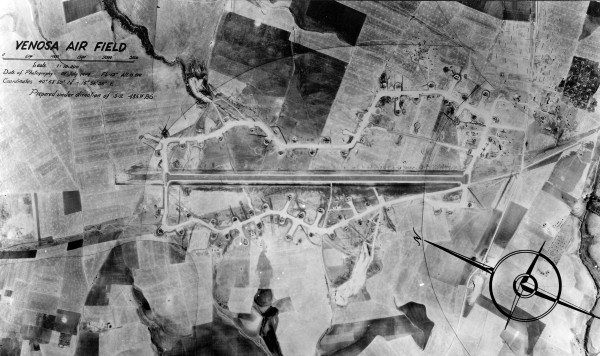
runway: 11/29 - ...x..m - PSP
Air field Venosa was a semi-permanent airfield located in Basilicata, approximately 300km southeast of Rome, near Cerignola, Apulia. The airfield was built from September 1943 by the United States Army Corps of Engineers with one PSP runway and a wooden control tower, as part of the Foggia Airfield Complex, a series of World War II military airfields located within a 25 mile (40 km) radius of Foggia. It had extensive taxiways and hardstand parking areas and a steel control tower.
The airfield opened in 14 March 1944, and became home to the 485st Bombardment Group (Heavy) of the US 15th Air Force, flying B-24 Liberators. The unit moved in in April and entered combat in May, engaged primarily in flying long range missions to targets in Italy, France, Germany, Austria, Hungary, Romania and Yugoslavia, bombing marshalling yards, oil refineries, airdrome installations, heavy industry and other strategic objectives. 485BG received a Distinguished Unit Citation for combating intense fighter opposition and attacking an oil refinery at Vienna on June 26, 1944. The last combat operations were flown in late April 1945 and the unit returned to the US in May 1945.
Venosa airfield in 1944 (storiedelsud.altervista.org)

Undated view of Venosa from the air. Bombers are still present in the dispersals, so it must be sometime between 1944 and 1945 (vintagewings.ca).

Undated photo of a B-24 Liberator of 485 Bomb Group taking off from Venosa (vintagewings.ca).

Undated photo of B-24 Liberators of 485 Bomb Group taxiing at Venosa (vintagewings.ca).

Venosa in 2006 with a smaller aerial photograph shot in 1944.
Venosa closed on 4 July 1945. Today the former air field is an agricultural area with almost no structures or any facilities in existence. Only a quonset hut, locally known as the hangar (although it is far from large enough for a B-24 bomber), remains. However, extensive evidence of land scarring still was visible in aerial photography in 2016.
 Venosa